Lesson 5: Land Use: Understanding Our Impact
In the last lesson, students investigated what happens to rainwater when it falls on different surfaces around their school. They observed that some surfaces allow water to soak into the ground through infiltration, while other surfaces cause runoff to flow across the landscape. They also discovered that runoff can carry pollutants such as sediment, trash, and oil into storm drains, streams, and rivers.
In this lesson, students build on those observations by exploring how human land-use decisions shape watershed health. They begin by constructing small-scale watershed models and simulating rainfall to observe how water naturally moves across the landscape. As they add roads, buildings, and other impervious surfaces, students investigate how development changes runoff, erosion (the wearing away and movement of soil and rock), and the movement of sediment (soil and rock particles carried by water). They then test conservation practices such as wetlands and riparian buffers to determine how these features can reduce runoff and slow erosion, helping to protect water quality.
After completing the hands-on investigation, students use a digital runoff simulation to extend their understanding beyond the classroom model. By manipulating variables such as land cover, soil type, and rainfall intensity, they investigate how these factors influence runoff, infiltration, and evapotranspiration (the combined movement of water from the land to the atmosphere through evaporation and plant transpiration). Comparing physical and digital models helps students recognize broader patterns and apply their understanding to real-world land management decisions.
Throughout the lesson, the emphasis is on explaining how human choices influence the movement of water through a watershed and how thoughtful land-use decisions can help protect freshwater resources.
Materials:
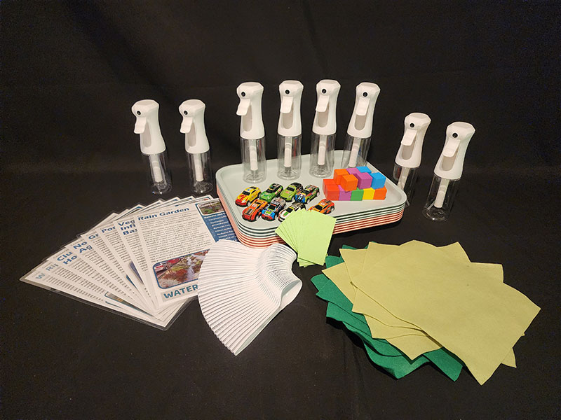
Materials provided in the :
- Activity 1: Erosion Table Materials (one per group)
- Conservation Practices Information Sheets (8 total laminated)
- Shallow tray (to model watersheds)
- Mist bottles (to simulate rain)
- Toy houses (small colored wooden blocks) and cars (to represent land development)
- Plastic spoons (for shaping landscapes)
- Conservation practice materials: Sponges (to represent wetlands), Fabric strips or felt (to represent riparian buffers)
- Pieces of plastic or plastic bags (to simulate roads, pavement, or other imperious surfaces)
Materials you will need to gather:
- Lesson Slides
- Activity 1: Erosion Table Materials (one per group)
- Erosion Table Investigation Handout
- Play sand (to create landscape features)
- Optional: Small rocks or pebbles (to simulate different land cover types)
- Activity 2: Runoff Simulation
- Activity 2: Runoff Simulation Handout
Activities:
Getting Started
This activity is best done outside — sandy water will overflow the shallow trays. Before class, set up erosion tables by filling shallow trays with wet play sand and slightly elevating one end with the ice cube trays from Lesson 3.
Each group will need:
- A mist bottle (to simulate rain)
- Small land-use items — toy houses, cars, roads
- Conservation materials — damp sponges for wetlands, fabric strips for riparian buffers, small rocks for different land cover types
Now that students have investigated how water behaves on different surfaces, they will build small-scale watershed models to explore how land use decisions influence runoff, erosion, and water quality.
Step 1: Building the Watershed
In small groups, students shape the sand in their trays to create hills, valleys, and a central stream channel. Ask: What did you just create? Guide students to recognize that they have modeled a watershed—an area where all water drains to the same body of water.
Before adding any human development, have students simulate rainfall by spraying water at the highest point of the model. Students should observe how water moves through the watershed and record their initial observations.
Step 2: Observing Erosion
Next, students add signs of human development to their watersheds. They may place roads, houses, parking lots, or other impervious surfaces in different locations throughout the model. Students simulate rainfall again and compare their observations to the undeveloped watershed.
As water moves across the landscape, encourage students to watch for evidence of erosion (the wearing away and movement of soil), deposition (the settling of transported material), and runoff. Ask: How did the movement of water change? Did runoff increase or decrease? Where did erosion occur? Where was sediment deposited? How did adding development affect the movement of water and sediment through the watershed?
Step 3: Testing Conservation Practices
Students modify their models using conservation strategies designed to slow runoff and reduce erosion. Provide students with the Conservation Practices Information Sheets to introduce riparian buffers, wetlands, and other conservation features. Have students strategically place sponges, fabric strips, or small rocks to mimic these practices within their models before simulating rainfall a third time.
Ask: How did the conservation practices affect runoff? Did erosion increase or decrease? How did the conservation practices affect the movement and deposition of sediment? Which conservation practice seemed most effective? Students should record observations from all three trials on the Erosion Table Investigation Handout and use their evidence to explain how land use decisions can either harm or protect watershed health.
To reinforce their hands-on investigations, students use the Runoff Simulation and the Runoff Simulation Handout to analyze how land cover, soil type, and precipitation levels influence water movement.
Step 1: Baseline Data Collection
Students first analyze runoff under normal conditions. Adjust the simulation settings as follows:
- Precipitation: 3 cm
- Soil infiltration: Moderate
- Land cover types: Developed – Open, Forest, Crops, Developed – Low
Students record how much water is lost to runoff, infiltration, and evapotranspiration, and compare how different land cover types impact water movement.
Step 2: Designing an Investigation
Students choose one variable to change on their own (precipitation, soil type, or land cover) and develop a research question and hypothesis. Encourage students to investigate questions related to land use whenever possible. For example:
- What happens when forest is replaced with development?
- How does increasing impervious surface affect runoff?
- What happens when developed land is converted to forest or other vegetated land cover?
After running their customized simulations, students analyze their data, identify patterns, and draw conclusions about how different land management choices impact watershed health. Which land cover types generated the most runoff? Which promoted the greatest infiltration? What evidence suggests that some land uses are more effective at protecting watershed health than others?
Step 3: Connecting to the Real World
Bring the class together to discuss:
- How did the simulation results compare to what we observed in the erosion table activity?
- How do different land cover types impact runoff and infiltration?
- What challenges might cities face during heavy rainfall? How could better land use design help reduce these challenges?
This simulation allows students to manipulate variables and see the impact of different land management decisions, reinforcing key concepts from their hands-on erosion table activity.
Adaptations & Extensions:
Extension 1: Enviroscape
Use an Enviroscape model. This 3D watershed model allows a class to explore the impacts of land use and human choices on the environment by simulating pollution and runoff. Enviroscapes can often be borrowed from your local conservation district or environmental center.
Extension 2: Sum of the Parts
Project WET’s drawing activity, Sum of the Parts, is a way for students to visualize a watershed and understand that human activities impact the entire watershed. Students collaborate and problem solve as they draw their land uses and make improvements to support watershed health.
Assessment:
Exit Ticket (CER Response): Use what you learned from the erosion model and the runoff simulation to answer the question below.
Question: How do people’s choices about how land is used affect runoff, erosion, and water quality?
- Claim
- Make a statement that answers the question.
- Evidence
- Use one observation from your erosion model and one result from your runoff simulation.
- Reasoning
- Explain how your evidence shows the connection between land use and watershed health. How can conservation practices help?