Lesson 4: Runoff Simulation
In the previous lesson, students explored their schoolyard and predicted where rainwater would flow after a storm. In this lesson, they'll discover where that water goes next.
To do this, we’ll use two interactive computer simulations to investigate what happens after rain falls on their schoolyard. Using River Runner, students follow a single raindrop as it travels from their schoolyard to the nearest stream or other waterway. Along the way, they'll watch small streams join larger streams, larger streams flow into rivers, and rivers eventually empty into an even larger body of water. River Runner lets students zoom out and see the entire journey from above, helping students discover that watersheds are nested - small watersheds join together to form larger watersheds. As they travel downstream, students will "meet" their watershed neighbors and discover an important idea: what happens upstream affects everyone living downstream.
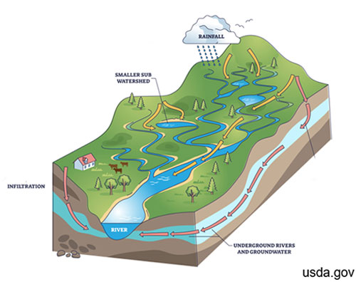 Next, students will explore the Runoff Simulator to investigate what happens to rain after it falls on the ground. The simulation shows that rain can take three different paths: it can run off the surface, infiltrate into the ground, or return to the atmosphere through evapotranspiration. The runoff is the water that travels across the land and eventually enters streams and rivers - the same journey students just followed in River Runner.
Now comes the fun part! Students can change the land cover, soil type, and even the intensity of the storm to see how each one changes the amount of runoff, infiltration, and evapotranspiration. They'll discover that healthy watersheds have more infiltration and less runoff. As communities become more developed with roads, parking lots, and buildings, runoff increases, carrying sediment and pollutants into nearby streams, rivers, lakes, and other waterways.
Materials:
Materials provided in the lesson 4 kit:
- Activity 1: n/a
- Activity 2: n/a
Materials you will need to gather:
- Lesson 4 slide show
- Activity 1 & 2: Computer/tablets
- Activity 2: Copies of Lesson 4 handout for each student
Websites:
Learning Objectives:
At the end of the lesson, students will be able to use a runoff simulation to describe how land cover, soil type, and storm intensity affect the amount of runoff.
Activities:
A difficult concept for students and adults to grasp is that watersheds are nested. What does nested mean? It means that larger watersheds are made of smaller watersheds. Here’s an example. Millersville University is in the Lower Conestoga River Watershed. This watershed is nested in a larger watershed called the Conestoga River Watershed, which is nested in the Lower Susquehanna Watershed, which is nested in the Susquehanna Watershed, which is nested in the Chesapeake Bay Watershed. WOW! That is a lot! What this means is that what we do in our little local watershed doesn't stay there. Our water keeps moving downstream, becoming part of larger and larger watersheds.
 Smallest to biggest... Lower Conestoga River Watershed → Conestoga River Watershed → Lower Susquehanna Watershed → Susquehanna Watershed → Chesapeake Bay Watershed
Your students live somewhere different, but the idea is exactly the same. Their local watershed is also part of a larger watershed, which is part of an even larger watershed. River Runner will help them discover what those watersheds are. Tell students that they are going to take a virtual float down their nearest stream to see where rain that falls on their schoolyard travels. Along the way, they'll "meet" all of their watershed neighbors and discover where their local watershed fits into the bigger picture. Open River Runner. Students will enter the school address into the location box and trace where water travels after it leaves their schoolyard.
As students explore, ask, "When rain falls on our schoolyard, where does it eventually end up?"
The answer will be different depending on where your school is located. For some students, the journey to the nearest ocean may be surprisingly short. For others, their water may travel hundreds or even thousands of miles, joining stream after stream and river after river along the way before finally reaching the ocean. The important idea isn't where the water ends up—it's that every school is part of a larger watershed. What happens in our schoolyard doesn't stay in our schoolyard. It affects everyone downstream.
Scientists often use computer models to better understand how the world works. Models allow them to ask "What if?" questions and test ideas before making decisions in the real world. Engineers, land planners, conservation organizations, and researchers use these models to predict how changes to the landscape might affect flooding, water quality, and stream health.
The Runoff Simulator is a simplified version of Model My Watershed®, a professional modeling tool developed by the Stroud Water Research Center. In the next lesson, students will use Model My Watershed® to investigate their own watershed. This activity serves as a gentle introduction, helping students explore how rainfall, land cover, and soil type influence where water goes when it rains.
Students can work independently, although we found pairs work especially well. Have students open the Runoff Simulator. Before giving them the Lesson 4 handout, give them a few minutes just to play. Encourage them to click on different land cover types, soil types, and rainfall amounts to see what changes. Resist the urge to explain too much during this time. Students are naturally curious, and this short exploration helps them become comfortable with the simulation before they begin the activity.
After a few minutes, bring the class back together and ask, "What did you notice?" or "What do you think this simulation is showing us?" Let students share their observations before passing out the Lesson 4 handout. The Lesson 4 handout includes three missions for students to solve: Can they create a watershed with the least runoff? Can they create one with the most runoff? Finally, if a huge storm was headed toward their school, what combination of land cover and soil would they choose to protect both their school and the communities downstream?
As students work, circulate around the room and listen to their conversations. Instead of giving answers, ask questions that encourage them to think more deeply. Why do you think that happened? What changed when you switched the soil? Why did the runoff increase? These conversations are often where the best learning happens.
When everyone has finished, bring the class back together to compare their results. You'll probably notice that different groups found different solutions, and that's okay. Use this discussion to reinforce the big ideas from the lesson: land cover, soil type, and the amount of rainfall all influence where water goes when it rains. Healthy watersheds allow more water to soak into the ground and produce less runoff, while developed landscapes tend to create more runoff. Help students make one final connection by returning to the idea of watershed neighbors. Every choice we make upstream affects the people and ecosystems downstream.
Assessment:
Students' responses on the Lesson 4 handout serve as the assessment for this lesson. As students complete the three missions, they demonstrate their understanding of how land cover, soil type, and rainfall influence runoff, infiltration, and evapotranspiration.